
Today’s bijou brainteaser is both accidental and personal. Beyond the break is a century-old Box Brownie snap of one of my great aunts. Can you help me identify both the photo’s location and date?
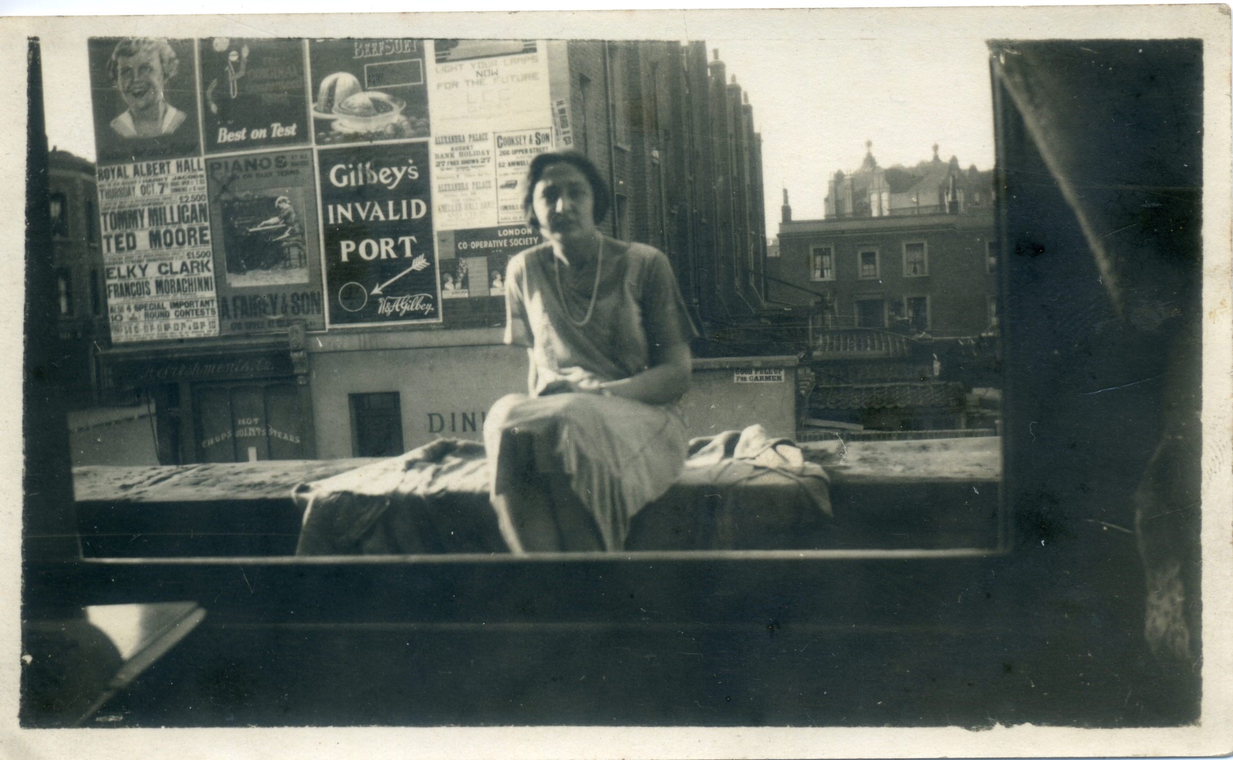
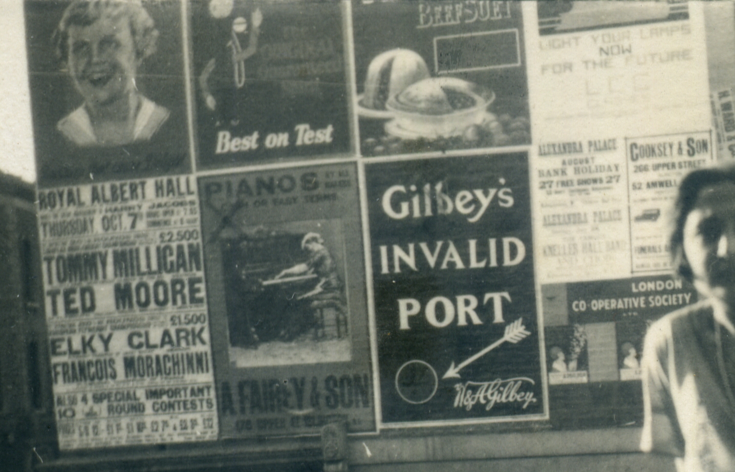
Thanks to these prominent billboard adverts…
…dating the picture should be relatively straightforward. The real challenge will be geolocating Auntie Vera’s lofty perch. Presumably somewhere in London – potentially somewhere radically transformed by the Luftwaffe during the war years – the spot boasts one fairly distinctive landmark…
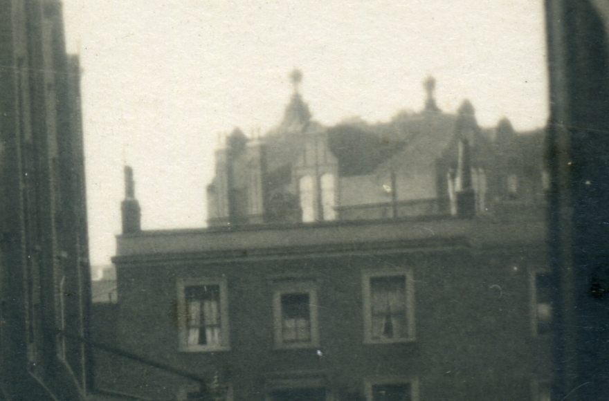
ID the building with the dutch gables and odd finials – something I’ve been unable to do – and this fotofoxer should be as good as solved.
* * *
SOLUTIONS
Friday Foxer # 262 (‘33 Things Wot are Spherical or Almost Spherical’)
1. SL = SLOE (CaptainBinky)
2. RP = EUROPA
3. MLTSR = MALTESER (Viscount)
4. CCHNNT = COCHONNET (Colonel_K)
5. SPBB BL = SOAP BUBBLE (Viscount)
6. BDNGBL L = BAODING BALL
7. SPCH PPR = SPACE HOPPER (Viscount)
8. RB BTDRPPNG = RABBIT DROPPING (Viscount)
9. VS TKDS CNTMDL = VOSTOK DESCENT MODULE (CaptainBinky)
10. BL CKPR LFT HBR GS = BLACK PEARL OF THE BORGIAS (CaptainBinky)
11. SWN GSMS TMPRS SVTRSTTT RCTN = SWANAGE’S MOST IMPRESSIVE TOURIST ATTRACTION (Colonel_K)
12. BHLDR = BEHOLDER (CaptainBinky)
13. RBCLM = ORBUCULUM (CaptainBinky)
14. BK NGBN = BAKING BEAN
15. NS DBLL = ANISEED BALL (Colonel_K)
16. FRRRR CHR = FERRERO ROCHER (CaptainBinky)
17. GNNSSWD GT = GUINNESS WIDGET (Colonel_K)
18. THR TNDRMDLL = THREATENED ARMADILLO (CaptainBinky)
19. FR TFT HL NDNP LN = FRUIT OF THE LONDON PLANE (CaptainBinky)
20. LFT LDG CKG G = LEAF-TAILED GECKO EGG (Colonel_K)
21. TRSTBS RVTNGN DL = TRIESTE’S OBSERVATION GONDOLA (Colonel_K)
22. STR GCNTN RFRV NYLCH LRD = STORAGE CONTAINER FOR VINYL CHLORIDE (CaptainBinky)
23. FLC NRYBLL = FALCONRY BELL (Viscount)
24. PNLMN TL = PAIN ELEMENTAL (CaptainBinky)
25. BL SHBCN = BELISHA BEACON (SunderLad)
26. CHN PSFLWR = ECHINOPS FLOWER (Colonel_K)
27. VRLSTNGGBS TPPR = EVERLASTING GOBSTOPPER (Colonel_K)
28. NHN DRDS D DDC = ONE-HUNDRED SIDED DICE (Colonel_K)
29. THFY LNGDLSR DMS = THE FYLINGDALES RADOMES (Colonel_K)
30. THC LV RB TFB R = THE CLEVER BIT OF A BIRO
31. THBS NS SN DFMR NN GST R = THE BUSINESS END OF A MORNING STAR (Zwack23)
32. THVN TRLTR RTFT HMM PHSB LL = THE VENTRAL TURRET OF THE MEMPHIS BELLE (Zwack23)
33. THR S NBM BSS DNT HL CBM BNG = THE ORSINI BOMBS USED IN THE LICEU BOMBING (Colonel_K)
Year = 1926
First boxing match between Tommy Milligan and Ted Moore for some middleweight titles on October 7th. Milligan won. Rematch in January of 1927, in which Milligan successfully defended his titles.
Since the bill for Alexandra Palace mentions the August Bank Holiday, I presume the photo was taken in mid to late summer.
Milligan defeated ‘Guardsman George West’ (it’s lack of names like this that explain the state of the country) on 12th July for the vacant British AND Commonwealth (formerly British Empire) middleweight titles. I presume the match against Ted Moore wouldn’t have been arranged until _after_ this date.
Amos Fairey & Son were in the piano trade ca 1906-1926.
They and Cooksey&Son were both in Upper Street, Islington, so we may well be around that area.
Fairey Amos & Son
– Lonsdale Square, Islington (1926)
– 178 Upper Street (1926)
https://www.lieveverbeeck.eu/Pianoforte-makers_England_f.htm
Cooksey and Son
– 266 Upper Street
– 52 Amwell Street
Similarly fancy finials can be seen at 154 Upper St (currently Aesop). Not quite the same, but similar.
The second photo here looks very similar, with the terraced backyards:
https://www.reddit.com/r/london/comments/1foevuj/carnaby_st_1966_islington_1960_holborn_1940/
It’s taken somehwere south of Pentonville Prison, maybe on Offord Road:
https://maps.app.goo.gl/HG1XbhdW9hf22Wya7
Correction, this is taken from St. Giles Church to the east. I take it it’s a common view but maybe it helps a bit visualizing the kind of parceling to look for.
My best guess so far after a consultation with the genius loci: the building in the background was possibly one of the 1870 Education Act board schools done in Queen Anne style.
The best example I could find is the one on Hanover Street, now Noel Road, with a strikingly similar layout:
https://www.gettyimages.in/detail/news-photo/hanover-street-schools-back-towards-canal-uk-britain-news-photo/464766713
Archiseek has a Lost Buildings section worth combling:
https://www.archiseek.com/buildings/england/london-buildings/lost-london/
(*combing) chief architect was Edward Robert Robson: https://en.wikipedia.org/wiki/Edward_Robert_Robson
After spending a couple of hours looking at pictures of LSB schools last night, I’m also convinced the big building in the background is one of Edward Robert Robson’s edifices. The size, height, and style, it all fits. The closest extant example I could find in the Islington area is this one:
https://thebridgetrust.academy/our-schools/hungerford-school/
Like the school in the photo, Hungerford School has two cupola-capped towers on one side.
At first glance this Bride Street location…
https://www.google.com/maps/@51.5460236,-0.1123814,3a,75y,149.18h,99.59t/data=!3m7!1e1!3m5!1scV0I8d723RS7TqEWD_rkuw!2e0!6shttps:%2F%2Fstreetviewpixels-pa.googleapis.com%2Fv1%2Fthumbnail%3Fcb_client%3Dmaps_sv.tactile%26w%3D900%26h%3D600%26pitch%3D-9.588991229829332%26panoid%3DcV0I8d723RS7TqEWD_rkuw%26yaw%3D149.17844093392333!7i16384!8i8192?entry=ttu&g_ep=EgoyMDI2MDQxNS4wIKXMDSoASAFQAw%3D%3D
…looks like a good match for the photo location, but the school is a big fly in the inkwell. If the photo was taken there then there would have to have been an LSB school very near St Clements Church – https://londonchurchbuildings.com/category/barnsbury/. Period maps show no such school.
Based on the perspective, the tall building doesn’t seem aligned with the buildings in front which are perpendicular, it’s at an angle. Or the street is curved and turning to the right.
Taking again the example of the Hanover Street School, it’s like you were looking west towards Noel Rd. from Baldwin Terrace. If it was not for the cupoles and the canal it would’ve been a great fit I think: https://maps.app.goo.gl/RJPwRt3T3aPyZxEY8
I suggest using Google Maps in Photogrammetry Mode (Layers → More → select Satellite and enable Globe View then click 3D under the compass and use Ctrl to rotate the view) or Bing Maps 3D (arrow keys to move).
Also, what do you make of this iron fence looking thing that seems to block the sidewalk: https://imgur.com/a/g3Ubeyo ?
I’m afraid Imgur is not accessible in the UK.
Something about them getting fined by the Office of Communications watchdog, not paying up, and consequently being blocked.
Other observations:
‘Good Pull Up for CarMen’ was apparently a thing for several decades
The sun is coming from the great aunt’s right and slightly behind ie. it’s not directly illuminating the wall of posters.
It’s also low in the sky as seen by the length of the great aunt’s shadow on the parapet, and the lack of obvious shadows in the street on the left.
I’m feeling it points towards early morning – there’s no sign of life at the refreshments place (I’m imagining it has the blinds rolled down; could be a Sunday, though), however, the nearer building on the right has curtains mostly drawn and windows open for (overnight) ventilation.
Consequently, I’m reckoning the picture was taken in early August 1926 between 6 and 7am and is looking south by east.
The left-most building has what could be a number 9 on it.
At first I was very confused about this Carmen and the reasons why she needed a good pull-up.
Here’s the photo shared directly from Google Photos. Is this a sort of gate?
https://photos.app.goo.gl/PAiYPwiBUNdo3uce6
This map could prove useful. Included in the final report of the LSB, it shows the names and locations of the 19 LSB schools in Islington:
https://archive.org/details/finalreportscho00reaygoog/page/n86/mode/2up
I think I may have found the location. It’s possible the photo was taken roughly 180 metres north of the north wall of Pentonville Prison at a house on St James’s Road near the junction with (the decidedly apt) Roman Road. The school in the background is to the NW on Caledonian Road. If you look closely at the aerial photograph linked below you can see the two towers on the western side of the school, and the two chimneys on the left corner of the southern side. The area looks very different today. No school, and most of the buildings on St James’s Road – now called MacKenzie Road – are post-war.
https://tallyhocorner.com/wp-content/uploads/2026/04/stjamesroad01.jpg
https://tallyhocorner.com/wp-content/uploads/2026/04/stjamesroad02.jpg
https://historicengland.org.uk/images-books/archive/collections/aerial-photos/record/EPW005751A
I think you’re right, the building with the posters must be 66 Roman Rd.
That means aunt Vera from Dutch Gables is at 36 St. James’s Rd.
See this insurance plan from 1901 on Wikimedia:
https://commons.wikimedia.org/wiki/Category:Goad_fire_insurance_maps_of_London_North_District#/media/File:Insurance_Plan_of_London_North_District_Vol._D;_sheet_28-1_(BL_152058).tiff
– the building is listed as a business, Oil & Color in 1901
– the buildings on the opposite sides have numbers from 91 to 95 (Colonel_K noted there might be a 9 on one)
Drawing of the school on Look & Learn:
https://www.lookandlearn.com/history-images/XJ104960/Caledonian-Road-School-London
I’m not sure what is more amazing – the fact that the LSB was building these palaces of education for ordinary working class kids, or that they went to the trouble of making each one unique!
I managed to find an actual photo showing part of the school:
https://www.alamy.com/caledonian-road-north-london-image183030010.html
Also if you zoom at max you can see that the chimneys match the photo (the two on the school & those on the Rhodes St. buildings): https://historicengland.org.uk/images-books/archive/collections/aerial-photos/record/EPW010954
It looks like the Luftwaffe can’t be blamed for the destruction of 36 St James’s Road. They damaged it, but, judging by the colouring on this LCC bomb map, the damage wasn’t terminal:
https://tallyhocorner.com/wp-content/uploads/2026/04/bombdamage.jpg
Obviously got to this rather late as it is solved, but I am now interested in the difference between Valid Port & Invalid Port…
I also had a bit of a fiddle, and I think the building behind her is this one, in this picture it is Wylie’s Bakery:
(Best picture was unfortunately on Facebook in a chat between people, one of whos ancestor used to live on St James’ Road)
https://www.facebook.com/photo.php?fbid=4040311016286203&set=p.4040311016286203&type=3
I therefore think it actually puts her on the corner of St James Road and Caledonian road, looking down the rear of the buildings on Caledonian road, which are still there on this Google View:
The rears of the buildings are certainly similar, but i’ve also been very wrong before!
https://www.google.com/maps/place/MacKenzie+Rd,+London,+UK/@51.5468186,-0.1175961,3a,75y,348.45h,88.24t/data=!3m8!1e1!3m6!1sBCdqPwdVBnr9jj2IioyH6Q!2e0!5s20080701T000000!6shttps:%2F%2Fstreetviewpixels-pa.googleapis.com%2Fv1%2Fthumbnail%3Fcb_client%3Dmaps_sv.tactile%26w%3D900%26h%3D600%26pitch%3D1.7604017198529789%26panoid%3DBCdqPwdVBnr9jj2IioyH6Q%26yaw%3D348.45157740861924!7i13312!8i6656!4m6!3m5!1s0x48761b7258da251d:0x63046165bc37df5a!8m2!3d51.5482182!4d-0.1147071!16s%2Fg%2F1tf47n01?hl=en&entry=ttu&g_ep=EgoyMDI2MDQxNS4wIKXMDSoASAFQAw%3D%3D
A not as wide picture if you can’t view the facebook link:
https://jbarchive.co.uk/products/lo-4619-st-james-road-holloway-london
Hmm, then again, the number of buildings to Rhodes Street looks more correct, so maybe it is that building but that is the one on the corner with Roman Road, sadly the photo doesn’t say.
Nice find. Judging by Aergistal’s insurance plan this is a photo of the exact spot. I reckon Vera was sitting on the narrow flat roof over the shop front at 36 when the picture was taken. If the location was close to the junction with Caledonian Road, the eastern facade of the school wouldn’t be visible.
It’s quite amazing to be able to see a photo of that exact random place more than one hundred years later.