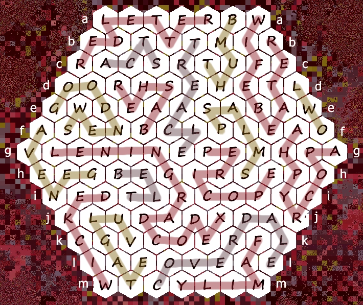
This week’s handmade co-op puzzle won’t defox itself. If you’re a dab hand at quizzes, lateral thinking, and search engine sleuthing, why not help out.
To fully defox the following geofoxer, identify all twelve locations plus the theme that links them.

* * *
SOLUTIONS
Last week’s hive foxer theme: the bible (defoxed by ylla)

acts (ylla)
apocrypha (Zwack23)
basher (ylla)
belt (Nutfield)
coverdale (Nutfield)
family (Nutfield)
geneva (Nutfield)
good news (Nutfield)
leningrad codex (Nutfield)
owl (ylla)
pericope (Zwack23)
psalms (Nutfield)
red letter (Nutfield)
thumb (Nutfield)
treacle (Zwack23)
vulgate (Mrs Nutfield, ylla, Zwack23)
wicked (ylla)
wifebeater (ylla)


D is Normanton church in Rutland Water
https://en.wikipedia.org/wiki/St_Matthew%27s_Church,_Normanton
I – Pann’s Bank Mural Sunderland
L seems to be Legoland Billund
X-Wing pilot’s face: blurred
Yoda: not blurred
https://www.google.com/maps/@55.73395,9.1266019,3a,59.8y,171.23h,83.41t/data=!3m6!1e1!3m4!1saks-Z1-Lt9Ur9h9XXQX2sw!2e0!7i13312!8i6656?hl=en&entry=ttu
E- W44th Street outside the Birdland Jazz Club (New York)
-Land is the connection?
B – Speedway ride at DreamLAND Margate
https://www.google.com/maps/@51.3853651,1.3767321,3a,75y,286.59h,103.8t/data=!3m6!1e1!3m4!1sAF1QipOCTuPYkQvsT_-9bXnNjonK2EMxt1x-LbrT3i9X!2e10!7i12248!8i6124?entry=ttu
B is a Speedway Ride, Built in 1934 by Orton & Spooner, it was in the Isle Of Sheppey, moved to Leighton Buzzard… No idea where :p
See last pic on this page:
https://littleboys.co.uk/project/speedway-ride/
It’s in Dreamland Margate (Or The Bembom Brothers when i used to go there as a kid)
K – DeHavilLAND Dove?
ETA: In fact it’s in the DeHavilland Aircraft Museum!
https://www.google.com/maps/@51.7108778,-0.2726756,3a,75y,149.44h,88.33t/data=!3m6!1e1!3m4!1sx8exyTxQyVpJJvJNYBtd0Q!2e0!7i13312!8i6656?hl=en-GB&entry=ttu
H = HeligoLAND lighthouse
https://en.wikipedia.org/wiki/Heligoland_Lighthouse
G – Lamb Inn Nomansland https://www.google.com/maps/@50.9545329,-1.6406933,3a,75y,358.19h,90.41t/data=!3m7!1e1!3m5!1snDodhGBQoekPcOOVBwNOvw!2e0!6shttps:%2F%2Fstreetviewpixels-pa.googleapis.com%2Fv1%2Fthumbnail%3Fpanoid%3DnDodhGBQoekPcOOVBwNOvw%26cb_client%3Dmaps_sv.tactile.gps%26w%3D203%26h%3D100%26yaw%3D190.94673%26pitch%3D0%26thumbfov%3D100!7i16384!8i8192?entry=ttu
(Mrs Nutfield)
C. FinLAND Station, St. Petersburg (maybe Roman is a Pet Shop Boys fan)
https://www.google.com/maps/@59.9561313,30.3575461,3a,63.7y,315.81h,89.94t/data=!3m8!1e1!3m6!1sAF1QipNGFrixkEZ_63MpBm0U9SXDCTi8LceEUJUn9Hoc!2e10!3e11!6shttps:%2F%2Flh5.googleusercontent.com%2Fp%2FAF1QipNGFrixkEZ_63MpBm0U9SXDCTi8LceEUJUn9Hoc%3Dw203-h100-k-no-pi-0-ya122.8523-ro-0-fo100!7i8704!8i4352?hl=en&entry=ttu
I’m fairly confident A. is in South Africa: it has the right sort of roadsigns, and those succulents seem to flower in July (from the Google pictures I’ve seen).
That’s about where I’m up to, too. The area code on those phone numbers looks right for a South African mobile, which doesn’t help to narrow it down.
Is it this sign, only pointing in a different direction?
https://www.alamy.com/stock-photo-brown-tourist-sign-to-the-noon-gun-above-cape-town-south-africa-29071906.html
More trapezoidal (?) like this one:
https://www.alamy.com/stock-photo-sign-to-colenso-battlefield-from-the-boer-war-kwazulu-natal-south-21708599.html
and what looks to be a single, middle-length word. Colenso has the right sort of flowering vegetation as well.
ETA: Roadsign might not be restricted to South Africa, could also be Namibia or Angola so far as I can see.
Yes, I was thinking about the logo rather than the sign shape. If it’s used for battlefields then that’s a start…
If it’s the answer I think then Roman’s gonna be looking at the uncomfortable end of an assegai:
Ulundi battlefield, King Cetshwayo Hwy, KwaZulu-Natal
https://www.google.com/maps/@-28.3113448,31.4249469,3a,28.2y,84.73h,88.74t/data=!3m6!1e1!3m4!1sZKcor47zS2UF-PT0V-L37Q!2e0!7i16384!8i8192?entry=ttu
Zululand then and Zululand District Municipality now?
Oh, well done! I thought of Zululand but that was still too big.
J. Scalloway, ShetLAND
https://www.google.com/maps/@60.1375361,-1.2795676,3a,61y,127.93h,85.11t/data=!3m7!1e1!3m5!1szYbxIm9UD6CQe4GaldjLEA!2e0!5s20150901T000000!7i13312!8i6656?entry=ttu
Just F. remaining, I believe.
OverLAND train: LeTourneau LCC-1 Sno-Train on display at the Yukon Transportation Museum in Whitehorse
https://www.google.com/maps/@60.7111437,-135.0806703,3a,29.3y,92.48h,90.16t/data=!3m7!1e1!3m5!1s_8nChvBnFPYU2-aRGoXMiQ!2e0!5s20220901T000000!7i16384!8i8192?hl=en&entry=ttu